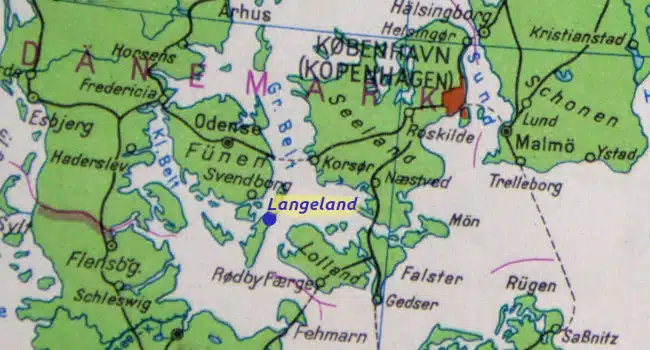
The narrow island of Langeland lies between the larger islands of Lolland and Funen and forms the eastern edge of the „Danish South Sea“. For cyclists and hikers alike, Langeland is a small paradise with quiet beaches, forests and hills, moors and picturesque settlements. I explored part of Langeland on a bike tour:
[Contains *advertising]
Between Tranekaer and Bagenkop – cycle tour on Langeland
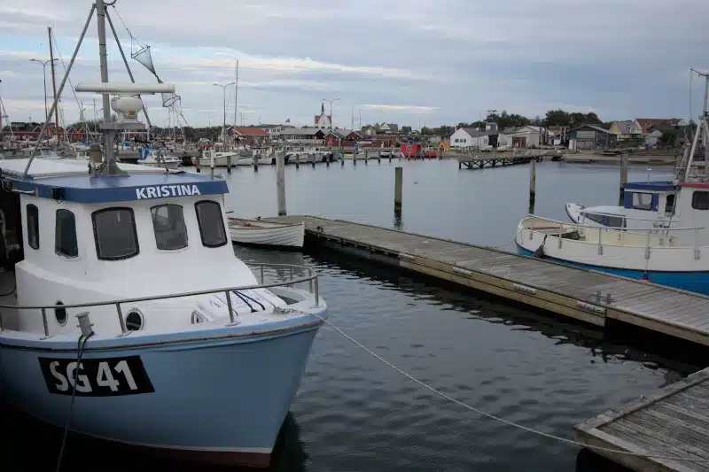
Arrival in Spodsbjerg
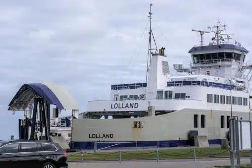
The ferry from Lolland takes me to Spodsbjerg, the small ferry town on the east coast of Langeland. After crossing Lolland as quickly as possible and, of course, always against the wind, I hope to find some nice and varied routes on the small Baltic Sea island. Spodsbjerg is not only the eastern ferry port of Langeland, but also a fishing village and, above all, a vacation village. The only harbor on the east coast facing the Langeland Belt offers plenty of space for Baltic sailors in a marina.
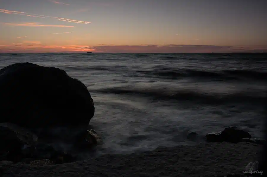
Next to the Spodsbjerg campsite I discover a snack bar and, as it’s lunchtime, I enjoy a tasty vegetarian burger. Spodsbjerg also has beautiful beaches – Drejet beach is very suitable for families with children because of its shallow waters. Despite it being late in the season in the second half of September, I take the opportunity for a swim – it’s warm and sunny for a long time this year.

Spodsbjerg is a good starting point for cycling tours. Several marked cycle routes pass through the town: the longest cycle route on Langeland is called the „Manor Route“ and is 160 km long. It leads through small villages and the most beautiful landscapes of Langeland in both the north and the south. In keeping with its name, it passes a number of the island’s manor houses and castles. Two sections of the Funen – Langeland hiking trails also meet at Spodsbjerg.
Tranekaer in the north of Langeland
From Spodsbjerg, I first head north. Via small side roads, a little up and down between fields, meadows and partly wooded „hat hills“, I head towards Tranekaer. On the approach between farms with low thatched half-timbered houses, I notice a large number of flea markets and flower stalls. Flea markets are popular everywhere in Denmark, and there are „Löpper“ tables or carts in front of some houses in almost every town. But in Tranekaer, the very first street I arrive in is like a single flea market.
This may be because Tranekaer is home to an „artists‘ colony“ and attracts a corresponding gallery crowd: Guests who bring with them a certain sense of historical pieces, interior design and home decor.
Landgrave Frederik Ahlefeldt-Laurvig (1760-1832), with his commitment to the development of Tranekaer and interest in art and culture, ensured that artists from near and far settled in his area – some of their descendants still live on Langeland today.
Tranekaer Castle and Castle Park
The landmark of Tranekaer is the castle, which stands on a steep hill. The castle itself has been privately owned by the Ahlefeldt – Laurvig family since 1659 and is unfortunately not open to visitors. But even the view from the outside forms a striking color contrast in the landscape. The castle is part of an estate with 1700 hectares of fields, meadows and woodland.
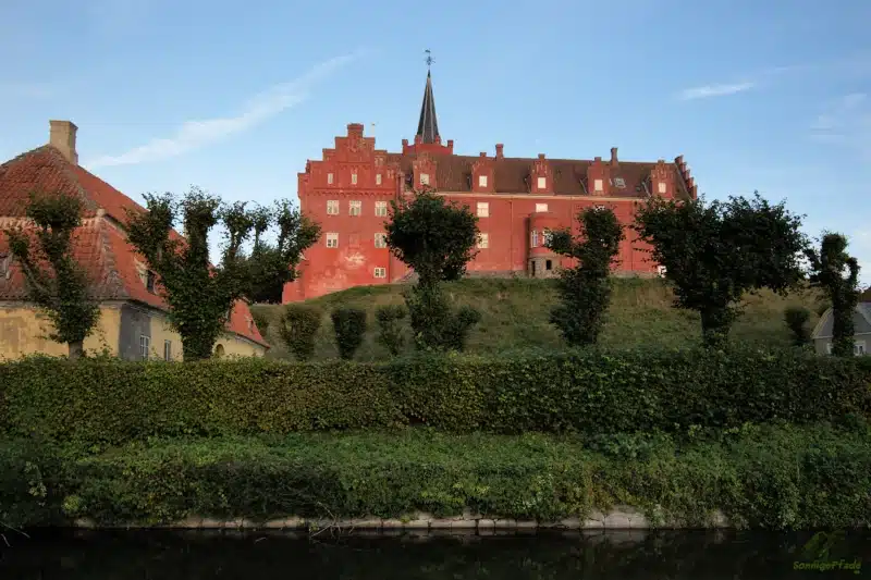
However, you can visit the castle park at the foot of the castle hill with its pond and forest park. Admission (25DKK for visitors aged 18 and older) is charged by mobilepay, which is widely used in Denmark.
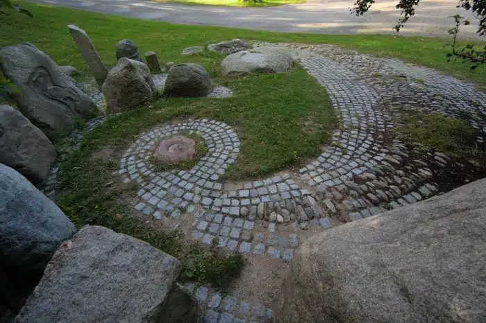
In the park area near the castle itself, artists from Denmark and far beyond have left their mark in the form of various land art objects. The aim is to use natural materials such as field stones, wood or cane from the region and to leave the artworks to weather. This means that the current 14 works of art will not be preserved or renovated and permanently maintained in a quasi-new condition, but will decay due to the natural effects of the weather. That is part of the concept. The art exhibition in Tranekaer Castle Park is run by the International Center for Art and Nature TICKON. Entrance to the castle park is on Botofte Strandvej, open from sunrise to sunset.
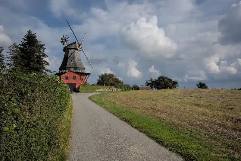
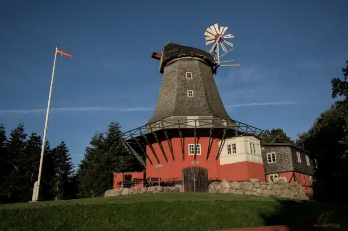
The Tranekaer Castle Mill
The Tranekaer Castle Mill stands on another hill a little to the north. This is a typical Dutch mill that was built in 1846. Today the castle mill is a museum where the original machinery of the mill can be viewed. During my visit, however, the windmill was missing its blades, so it was not possible to operate it. Since I now also know pictures of the mill with wings, it can be assumed that the wings were only temporarily removed here due to renovation work.
There are other beaches near Tranekaer, e.g. east at the Langelandbelt near Botofte or northwest of Helletofte.
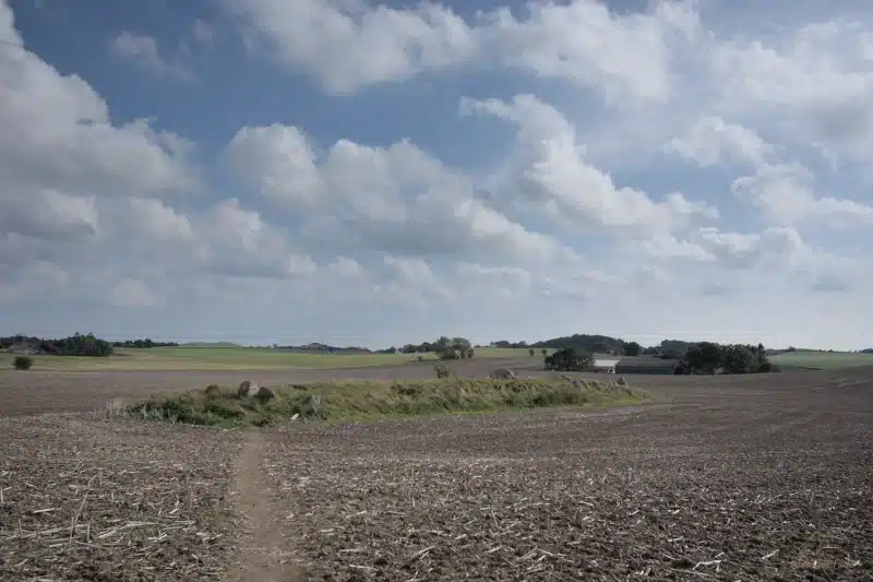
On the way to southern Langeland
From Tranekaer, I set off south again. This time my route takes me more through the woods west of the main road 305. On the way I come across Kong Renes Høj, a megalithic grave from the Stone Age. At Paeregard Skov, I catch up with four young girls who are also on their bikes. They must have set off again before their studies to experience an adventure together on the Danish islands. We cycle together as far as Rudkøbing. But while they head straight onto the high bridge towards Fynen, I turn off towards the small harbor town on the west coast of Langeland.
Rudkøbing
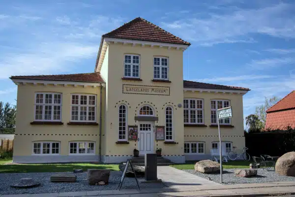
The small town of Rudkøbing is practically the „island capital“ of Langeland. A historic fishing port and low old town houses characterize the town center. However, the tradition of the merchants who left their mark on the town center with their houses has now been passed on to department store chains such as SuperBrugsen. In Rudkøbing, you can visit artisan galleries and an artists‘ quarter, eat at Café Gaardhaven or at the fish smokehouse „Fisk & Røgerie“. The ferries to Strynø and Marstal on the island of Aerø depart from the southern part of the harbor. Rudkøbing is the birthplace of H.C. Ørsted (1777-1851), who discovered the phenomenon of electromagnetism. An exhibition and a monument at Gasetorved are dedicated to him. You can also visit the Langeland Museum in Rudkøbing.
Humble – Kong Humble’s grave
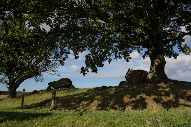
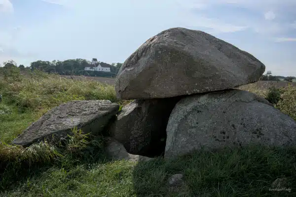
But I’m drawn further south, so I’m soon on the road again. My next stop is the village of Humble. Here I’m particularly interested in one thing – Kong Humble’s grave.
I read somewhere that this is the grave of an old Viking prince. But that’s probably not true, it is around 4000 years old and was built well before the Viking Age (792-1066). A travel guide also said that it was „right next to the late Romanesque church“ of Humble. Well, distances are relative… and the sight distance to the prominent church standing on a hill is already given. However, access to the grave is only possible via an open field from the village of Kædeby to the north. There you first cross the chippings yard of a construction company, walk along a hedge path and then follow a beaten track across a freshly plowed field. This is often the case in Denmark and is tolerated by the landowners. It’s a good thing that my Garmin can help me reliably.
Kong Humble’s Grave is a 55x9m long dolmen grave with a stone setting at the edges and the still indicated entrance to the burial chamber between a rock gate.
The name Humble „sounds“ somewhat English, at least in written form, but probably comes from the Danish compound „Humlæthwet“. This is a reference to Humle – the hops and Tved – the clearing. So at some point, forest was cleared here to grow hops.
Artists and art lovers have also settled in Humble. Gallery no. 44 on Ristingevej has been open since 2021 and an old transformer tower has become Art Tower 8 by Hanne Biben Mortensen. If you are interested in buying art, you can also visit the Schytz Haaning Art store and Gallery.
Tryggelev Nor / Noerreballe Nor
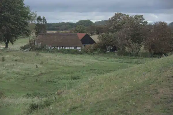
I have a right turn today – from Humble I am once again traveling as far west as possible on the island roads of Langeland. The landscape is characterized by numerous individual farmsteads and small settlements with only a few houses, often with thatched roofs and half-timbered houses. In between are mainly fields, fortunately not as vast and endless as on Lolland, but interspersed with field hedges, meadows and hills. Thanks to the hedges, the wind, which ‚always comes from the front‚, is not a problem. At Hjesselberg I come across another stone settlement, a long dolmen on the northern edge of Noerreballe Nor. Next to it, at an obvious wetland, is a parking lot. A wildlife photographer with a huge telephoto lens is sitting there in a van.

Noerreballe Nor and the associated Tryggelev Nor directly on the coast is a nature reserve and it is fall. Many migratory birds leave the Scandinavian north at this time of year to seek out their wintering grounds further south. Water areas and marshes such as Tryggelev Nor are resting places on the long journey. Good opportunities for ornithologists and wildlife photographers to discover many a bird that doesn’t necessarily fly around everywhere all year round. Apparently, many Danes are very keen on nature, as there are usually large parking lots and signposted lookout points for undisturbed observation at such nature reserves.
Bagenkop – the southern harbor of Langeland
Passing Klise Nor, another wetland, I finally reach Bagenkop. This small town on the south-western tip of Langeland has a sailing and fishing harbor and a fine sandy beach to the north. Before the introduction of the €uro, Bagenkop was even connected to Kiel in Germany by ferry. However, with the abolition of duty-free shopping on board, the „butter trips“ were no longer profitable and the ferry service was discontinued. In the meantime, the ferry berths have been dismantled and made way for a colony of vacation apartments.
For sailors on the western Baltic Sea, however, Bagenkop is all the more attractive as a gateway to the „Danish South Sea“ with its many small islands and for buying provisions, as the town does have a Dagli Brugsen supermarket.
In summer, music is played on the open-air stage at the marina and artists open exhibitions, and Bagenkop also organizes a harbour festival.
In the very south of Langeland – Dovns Klint and lighthouse Keldsnor Fyr
The southern tip of Langeland at Gulstavs Klint and Dovns Klint are large nature reserves. You can hike from Bagenkop to Gulstavs Klint on several routes, and there are also bridle paths. By bike, however, I use the smaller asphalted roads past Fakkebjerg (37m, viewpoint) on Gulstavsvej. A group of ornithologists with binoculars and spotting scopes are already standing on a hill next to the information center at the Oestre Gulstav forest. The elongated island serves as an orientation point for migratory birds, which fly directly over the southern tip of Dovns Klint across the Baltic Sea – and are counted by the birdwatchers.
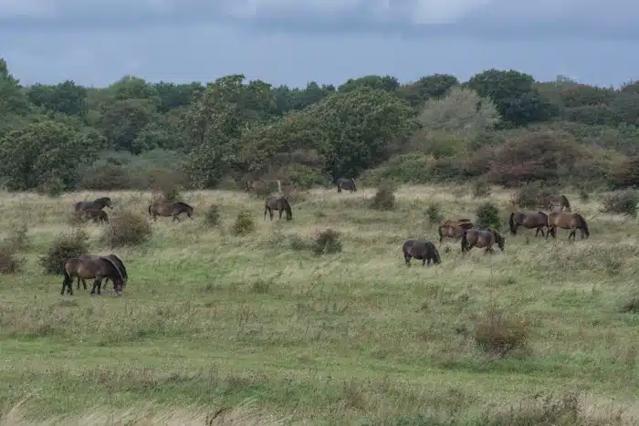
The large open areas at Gulstav Mose are fenced off. You can enter the area via portcullis on the hiking trails, but you have to close the gates properly. This is because a large semi-wild herd of Exmore ponies (I counted about 50 animals) graze here and ensure that the marshy meadows do not become overgrown. As a result, the open land remains a species-rich biotope with a variety of flowering plants, specialized insects and ground-nesting birds. So if you are interested in nature, you can rent a vacation home in Bagenkop and spend days in the rich surroundings observing nature at any time of year.
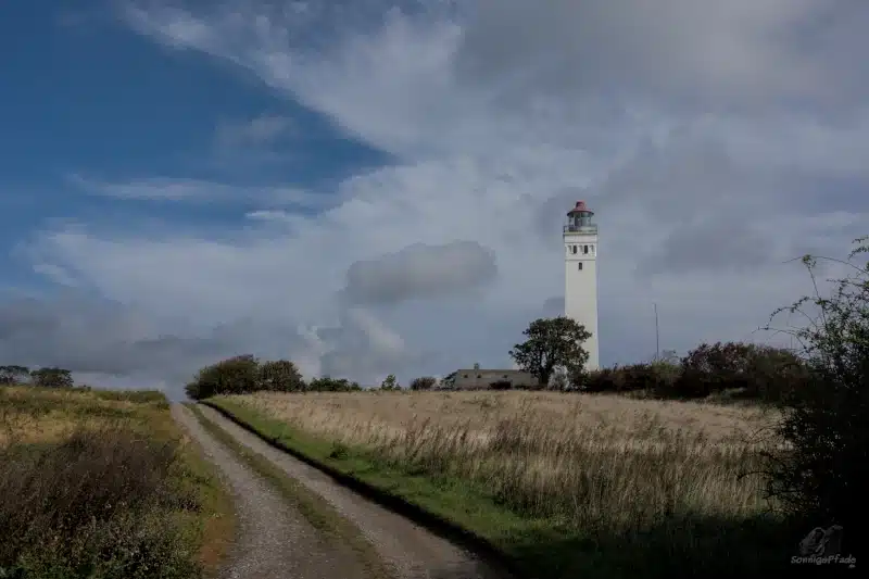
To the east of Dovns Klint, Keldsnor forms a large lagoon, which is only separated from the open Baltic Sea by a narrow spit of land. Logically, this is a paradise for water birds of all kinds, be it in summer for breeding birds or in fall and winter for migratory species. I can reach Keldsnor Fyr, the lighthouse at the entrance to Langelandsbelt, by bike via another small path.
Langelands Fortet
To the east of Bagenkop is a former military facility – the Langelandsfortet. Today this facility is a Cold War museum and part of the Langeland Museum. After the Second World War and the beginning of the East-West bloc confrontation in the early 1950s, an extensive military complex was created here, partly with underground bunkers, from which the Danish army directed its „ears“ towards the southern Baltic Sea. The exhibition in Langelands Fort now provides information about this. You can also see weapons and military technology such as the Danish submarine „Springere“, wheeled tanks, 150mm guns, anti-aircraft guns and two fighter planes – a Saab from the Danish Air Force and a Soviet MiG23. http://langelandsfortet.dk/
Return along the east coast
Although I want to leave Langeland in a westerly direction, i.e. towards Fynen, from Humble I take the route more to the east of the main road. Past the beautiful Dutch mill (with wings!) near Kædeby and back to Spodsbjerg. I loved the veggie burger, hard to believe! Well, it’s lunchtime again and the right time for a hearty hot meal and the burger was definitely better than anything you can get in fast food chains. And so I don’t have to drive into Rudkøbing again and look for another restaurant. The 9 km across the island to the bridge are quickly completed, well fueled. More beautiful adventures and varied episodes await me on Fynen …
Travel tips Langeland in Denmark
Getting to Langeland
Next airport to Langeland is Copenhagen airport in the east and Billund airport (with the origin LEGO-land park) in the west. You can go to Fyn island by train and from Odense or Svendborg to Langeland by public bus.

The island of Langeland has two entrances fairly centrally – from the east at Spodsbjerg and from the west at Rudkøbing. From the east, you can only get there by ferry from the Danish island of Lolland, which in turn can be reached via the Vogelfluglinie (birds flying route Puttgarten on Fehmarn to Roedby) from western Germany or from Rostock in eastern Germany by ferry to Gedser on Falster and a bridge at Nyköbing/Falster. All the ferries mentioned can be used by car as well as by bicycle or on foot.
From the west, Rudkøbing can be reached from the Danish island of Fynen via bridges (Tåsinge, another small island, lies in between). Fynen can be reached directly from Flensburg by ferry or via the long arch through Jutland and then over a bridge.
If you want to go island hopping in the Danish South Sea, you can also travel by ferry from Flensburg/Sønderburg and via the island of Aerø to Rudkøbing.
The island of Langeland is served by Fynbussen. So if you want to travel by public transport, you can travel to the island of Fynen by bus or train (e.g. Svendborg or the island’s capital Odense) and from there take a Fynbus to Langeland. www.fynbus.dk
Cycling on Langeland
I hope my brief impression has whetted your appetite for cycling! There are almost no cycle paths on Langeland, but there are small side roads, forest and field paths. There is rarely a car.
Several „official“ cycle routes are signposted. Already mentioned above is the approx. 160 km long „Herregards“ route. Also on North Langeland the cycle route 80-81 (72km Rudköbing – Lohals – Spodsbjerg) and the cycle route 82-83 (65km, Rudkoebing – Bagenkop – Spodsbjerg) on South Langeland, whereby the route runs parallel to the „Manor House“ route, at least in parts.
For longer pre-planned cycle tours and also hikes, I usually use a Garmin hiking GPS device and gpx tracks, which I put together on openrouteservice.org as I would like (basis „cyclist – recommended„)
Hiking on Langeland
Langeland is part of the South Fynen Archipelago Geopark (Det sydfynske øhav). One of the Geopark’s projects is the hiking trail that runs across the south of Fyn, the island of Aerø, the island of Tasinge and Langeland. Yes, you don’t have to be in the mountains to go hiking! You can also do it in the lowlands. Two stages of the trail run across Langeland: part 5 from Lohals in the north via Tranekaer to Stengade Strand near Spodsbjerg and part 6 from Spodsbjerg via Rudkøbing to Lindelse Nor bay.
For each stage, the Geopark Det sydfynske øhav provides a large flyer with a map at a scale of 1:50,000 and lots of information about places of interest, geoinformation, historical anecdotes etc. at stops along the way. The hiking trail runs along field and forest paths, beach sections, but also partly across meadows and forest edge zones. There it is mown down to grass level for recognition and easier walking. Small wooden posts with marker plaques provide orientation. https://www.geoparkoehavet.dk/
English: https://www.geoparkoehavet.com/
Weather conditions
The overview opposite gives you the weather on Langeland for today and the next three days to help you plan your tours.
Accommodation on Langeland
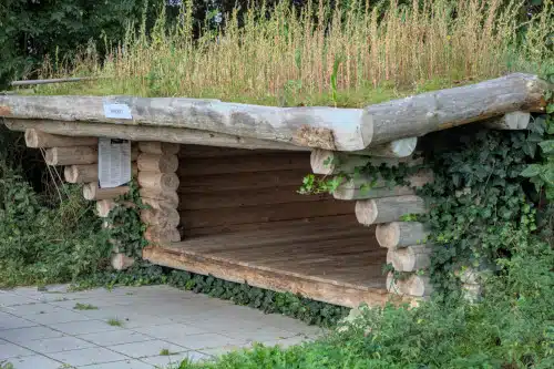
If very simple accommodation without any comfort is enough for you, you can also sleep in shelters on Langeland and Fyn. These are simple wooden shelters with a wooden floor that protect you from wind and rain and can be used with your own sleeping bag and sleeping mat. Information and booking via www.bookenshelter.dk
Near Spodsbjerg in the middle of Langeland there is a small vacation home with 2 bedrooms* with kitchen and fireplace. The garden can also be used for a relaxing stay. In addition to the bathing opportunities on the beaches of Spodsbjerg, the natural forests are particularly attractive, such as the Longelse Bondegårdsskov, which has not been used commercially since the 1980s and is a nature reserve with rich vegetation, wildlife and a diverse bird population. There is free parking next to the vacation home. Spodsbjerg is the ferry port to Lolland.
A cozy vacation home in Tranekaer* with three bedrooms is available to guests for visits to the north of the island of Langeland. There is a fireplace in the living area and a fully equipped kitchen in the house. The garden can also be used, e.g. for a barbecue. In addition to the beaches on the east and west coasts of Langeland, you can visit the castle garden with its changing art or the castle mill in Tranekaer. Free parking is available at the accommodation.
A large, bright vacation home* for small groups with 5 bedrooms is located in Humble in the south of Langeland. The house has a sauna and a well-equipped kitchen. Guests can also use the barbecue equipment in the garden. Pets are allowed. Sandy beaches are always close by on Langeland. In the surrounding area you can go hiking and cycling, fishing or play golf. Free parking at the vacation home.
Small families can use the Annekset vacation home* in Bagenkop in the very south of the island of Langeland island. There are two bedrooms, each with two beds. The house has a conservatory in case of bad weather. There are barbecue facilities in the garden. Parking is available free of charge at the vacation home. Bagenkop has a large public beach with changing rooms, showers and toilets.
The 3-bedroom vacation apartment* in Bagenkop is suitable for up to 6 guests. The apartment has a kitchen with dishwasher and two bathrooms. This accommodation does not have its own parking spaces, but there are plenty of public parking spaces in the surrounding area. From Bagenkop you can go on beautiful excursions to the nature reserves on the southern cliffs of Langeland or visit the Cold War Museum “Langelandsfortet”.
Reference to *advertising links
Some of the links in this article are marked with *. These advertising links will take you to agencies or online stores. If you make a purchase there, the sunny trails blog will receive a small commission to cover the technical costs. Nothing will be more expensive for you, as the commission has already been taken into account by the store operators in the pricing.